Gritstone edges, deep limestone dales, and wide-open moorland horizons define the visual soul of England’s first national park. These viewpoints matter because they reward walkers, photographers, and casual explorers with sweeping perspectives that change dramatically with light and season. Sunrise mist over valleys, sunset glow across escarpments, and quiet hilltop panoramas all shape unforgettable outdoor moments. Smart planning helps visitors choose the right routes, parking points, and walking times to reach the finest lookouts without wasted effort. This guide to the best views in the Peak District highlights iconic vantage points, quieter alternatives, and practical access tips so every visit delivers scenery worth the climb.
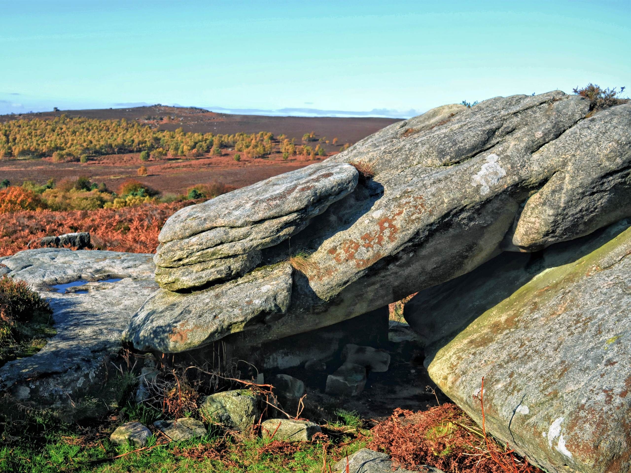
Stanage Edge Balcony Cave View

High above the Hope Valley, a narrow stone recess carved into gritstone opens onto one of the Peak District’s most recognizable panoramas. This sheltered hollow along Stanage Edge frames sweeping views across patchwork farmland, distant ridgelines, and the rolling Derwent Valley below. Climbers rest here between routes, walkers pause to take in shifting light, and photographers favor the natural framing created by the cave-like overhang. Wind exposure remains constant at this elevation, shaping weather patterns that move rapidly across the landscape. On clear days, Hathersage sits sharply defined below, while Kinder Scout rises faintly on the horizon. The walk-in route follows well-marked paths along the edge, making access straightforward without technical climbing. Rock textures here display classic millstone grit formations, weathered into rounded ledges and fissures. Sunrise casts low-angle light across the valley floor, while late afternoon shadows stretch dramatically across the moors. Despite popularity, quieter moments arrive between peak visiting hours. This viewpoint combines shelter, geological character, and far-reaching visibility in one compact setting that consistently rewards careful timing and steady observation.
Over Owler Tor Dawn Ridge
Early morning light spills across a broken spine of stone above the Upper Derwent landscape, revealing a ridge that feels far removed from nearby trails. Over Owler Tor rises subtly rather than sharply, yet its exposed crest delivers unexpectedly broad horizons. Heather, coarse grass, and scattered grit outcrops define the approach, with skylarks often audible long before the sun clears the horizon. This location gains its strongest impact at first light, when the valley mists lift slowly from the reservoirs below and illuminate distant moorland contours. Unlike higher summits, the atmosphere here feels intimate, with gentle slopes flowing outward instead of dropping abruptly. Weather changes remain visible from every direction, making this ridge useful for tracking incoming cloud bands from the west. Walkers often combine this point with nearby Derwent Edge routes, yet the tor itself stays comparatively quiet. Subtle elevation and uninterrupted views create a calming sense of openness rather than dramatic exposure. Seasonal shifts transform the ridge palette from soft spring greens to autumn rust tones and winter frost crusts. Dawn here emphasizes stillness, balance, and understated scale rather than raw vertical drama.
Combs Moss Moorland Summit

A wide plateau of peat, heather, and weather-polished stone stretches outward once the open crest of Combs Moss is reached. Sitting above the Goyt Valley, this high moorland summit feels expansive rather than towering, with visibility that often extends toward Kinder Scout, Shining Tor, and the distant Cat and Fiddle ridge. The approach crosses rough grazing land where stone walls trace centuries of agricultural boundary work. Underfoot, springy peat alternates with gritstone slabs exposed by erosion and livestock movement. Unlike crag-backed viewpoints, this summit offers uninterrupted sky and sweeping lateral sightlines instead of sheer drops. Wind presence remains a defining feature, shaping low vegetation into flattened patterns that ripple across the plateau. On clear days, cloud shadows move across the hills in slow, continuous sheets. Walkers often pass through en route to longer circuit routes, yet lingering here reveals subtle shifts in light that change the mood minute by minute. Snowfall transforms the moss into a high-white plain during winter, while summer brings purple heather bloom across large sections. The summit’s value lies in its scale, openness, and long-distance continuity rather than vertical intensity.
Padley Gorge Woodland Falls
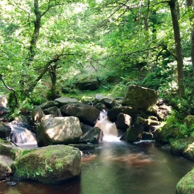
Deep within an oak-lined ravine near Grindleford, narrow footpaths follow a tumbling stream that drops over layered gritstone steps. Padley Gorge compresses sound, motion, and texture into a confined space where water movement remains constant throughout the year. Moss-covered boulders, leaning birch trunks, and exposed root systems frame small cascades that surge after heavy rainfall. The gorge differs sharply from open-edge viewpoints by enclosing the visitor within shaded rock walls and dense canopy. Light filters in broken fragments rather than broad shafts, giving the area a cooler, subdued character even in summer. Millstone grit layers appear stacked and fractured along the stream corridor, showing clear geological banding formed over millions of years. The trail network connects with Longshaw Estate routes, making access straightforward while still preserving a secluded feel. Seasonal leaf fall increases visibility during autumn, while spring brings strong water volume and fresh green understory growth. Wildlife sightings often include dippers, wrens, and amphibians near damp ledges. This setting offers visual immersion at close range rather than wide-distance surveying, focusing attention on movement, sound, and surface detail.
Bamford Edge Reservoir View
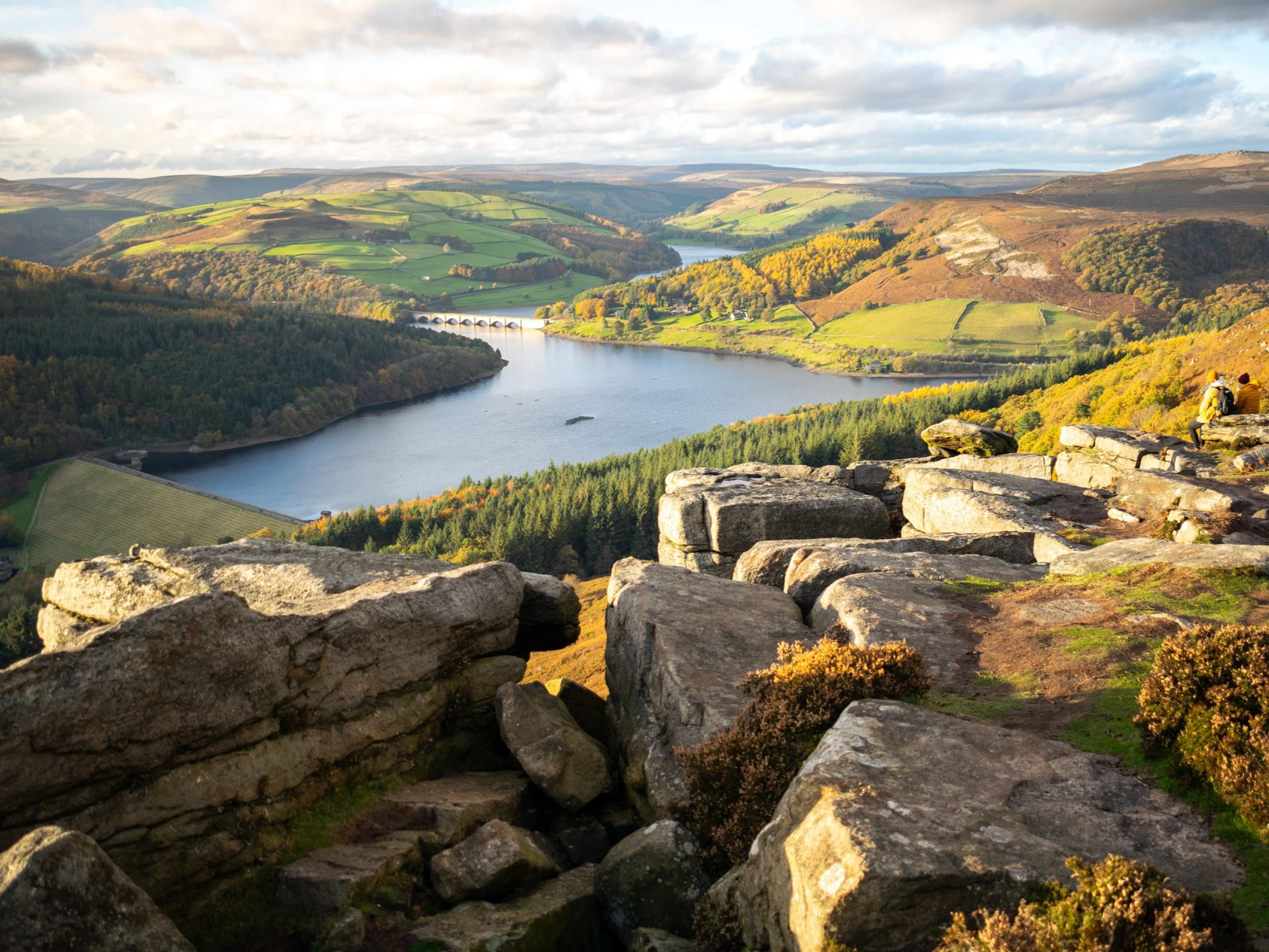
Stone ridges rise sharply above the waters of Ladybower Reservoir, placing this viewpoint between reflective water surfaces and wide upland horizons. Bamford Edge presents a layered visual composition where gritstone tors sit above steep slopes that drop toward flooded valleys below. Morning mist frequently lingers over the reservoir, creating soft atmospheric separation between water and surrounding hills. The footpath climbs steadily through rough grass and rocky shelves, reaching an exposed crest where wind patterns shift quickly. From this point, Win Hill dominates the opposite skyline, its symmetrical rise mirrored faintly on calm water. Seasonal changes dramatically affect the color palette, shifting from winter steel-grey to summer green and autumn gold. Cloud movement across the Derwent Valley becomes part of the visual experience, especially during fast-changing weather. Walkers often arrive here for late-day light when the reservoir reflects long bands of color beneath shifting skies. Despite popularity, the broad ridge allows space for quiet observation away from the busiest edge sections. The contrast between open water, steep terrain, and elevated rock creates a balanced composition that remains visually engaging in any season.
The Roaches Ridge Vista
Rising abruptly from Staffordshire moorland, this rugged escarpment presents narrow spines of gritstone that command both the Cheshire Plain and the distant hills of the southern Peak. The Roaches form a broken wall of weather-carved rock, where vertical faces drop sharply into wooded gullies and rolling pastureland beyond. Approaches wind through heather, bilberry, and rough grass before reaching exposed terraces that stretch along the ridge. Climbers occupy many of the sharper formations, while walkers gravitate toward the broad ledges overlooking expansive lowland views. On clear days, the flatlands extend far toward the Midlands, contrasting strongly with the elevated moorland foreground. Wind tends to accelerate along the edge, intensifying the sense of height even though true elevation remains moderate. Rock textures here are especially varied, showing honeycombing, cracks, and iron-stained streaks. Cloud inversions occasionally flood the valleys while the ridge remains sunlit above. The Roaches deliver one of the Peak District’s strongest vertical transitions between upland and plain within a relatively short walking distance, making visual drama immediate rather than gradual.
Thorpe Cloud River Overlook

A steep limestone cone rises sharply beside the River Dove, separating fields and floodplain from sudden high ground. Thorpe Cloud’s compact form creates a rapid transition from valley floor to open summit in a short ascent. Limestone steps and winding paths climb through exposed grass and scattered rock ledges toward a rounded crest overlooking Dovedale’s winding river corridor. From the top, the ribbon-like River Dove curves tightly between pale limestone slopes below, forming one of the region’s most recognizable valley profiles. Unlike gritstone edges, this hill’s pale rock reflects light strongly, giving the setting a brighter, drier appearance under clear skies. Seasonal contrasts remain pronounced, with winter frost accentuating rock texture and summer highlighting grazing pasture patterns. Foot traffic concentrates on the main ascent route, but multiple viewing points exist slightly off the central crest. The summit offers full visibility of surrounding valley loops, footbridges, and limestone buttresses. Despite frequent visitation, the sharp rise and narrow peak maintain a feeling of separation from the busier trails below. The interplay between water, pasture, and pale rock defines this viewpoint’s distinctive character.
Win Hill Patchwork Hills

A steady climb above the western shore of Ladybower Reservoir leads toward a broad summit that commands both upland moor and cultivated lowlands. From Win Hill, the surrounding terrain displays a stitched pattern of fields, reservoirs, ridges, and minor summits arranged in layered tiers. The ascent follows well-graded paths through rough pasture before transitioning into shorter heather sections near the crest. On clear days, the Hope Valley opens sharply to the south, while Kinder Scout forms a continuous high skyline to the north. Reservoirs below catch shifting sky color, acting as reflective anchors within the wider landscape. Wind exposure increases near the summit plateau, often bringing moving cloud bands that alter light intensity across the hills in minutes. Unlike narrow ridges, Win Hill’s top feels open and balanced, allowing wide viewing angles in all directions. Sunrise and late afternoon offer the strongest contrast between illuminated peaks and shaded valleys. Seasonal agricultural changes subtly reshape the visible geometry of fields below. This viewpoint stands out for its compositional clarity, where natural and managed landscapes interlock with unusual precision.
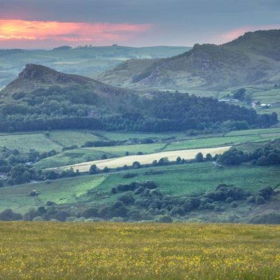
Chrome Hill Dragon’s Back Ridge
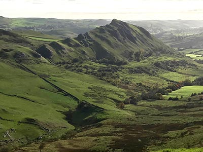
Sharp limestone curves rise above the Upper Dove Valley in a sequence of narrow crests often likened to the spine of a mythical creature. Chrome Hill’s steep, fin-like form differs entirely from the gritstone edges that dominate much of the Peak District. The path follows a narrow ridge with abrupt drops on either side, producing strong height awareness despite modest absolute elevation. Below, the River Dove loops tightly through bright pasture, creating constant motion within an otherwise static limestone framework. Rock surfaces appear fractured and pale, catching light aggressively under open skies. The climb includes short scrambly sections that require careful footing, particularly after rain. From the upper ridge, sightlines stretch across neighboring Parkhouse Hill and toward the Dove Valley mouth. Wind exposure remains strong along the narrow crest, amplifying the feeling of exposure without technical risk. Seasonal color contrast becomes dramatic, with white limestone standing against deep green summer fields and frost-coated slopes during winter months. Chrome Hill’s appeal lies in its distinctive shape, tactile ridge walking, and concentrated viewpoint intensity across a short, memorable route.
Youlgreave Valley Hillside View
High above a limestone village known for its stone bridges and clear streams, sloped pastureland rises toward a quiet hillside outlook overlooking Lathkill and Bradford valleys. This viewpoint delivers layered valley depth rather than sharp vertical drama, with woodland belts following river paths far below. Dry-stone walls grid the slopes into soft geometric divisions that shift with grazing patterns through the year. The position remains sheltered compared to exposed ridges, making it suitable for calmer conditions when higher ground turns hostile. Light movement across the valley floor becomes especially noticeable during cloud-broken afternoons, where patches of brightness drift slowly across pasture and woodland. The village of Youlgreave anchors the scene with pale stone structures that contrast gently with surrounding greenery. Springs and caves within the valley contribute to seasonal water variation, affecting river clarity and vegetation density. The viewpoint’s value lies in its balanced scale, showing both settlement and surrounding rural structure within a single frame. Without dramatic cliffs or edges, the scene invites extended observation rather than quick visual impact. This hillside perspective showcases how human settlement and natural limestone landscapes coexist with quiet visual harmony.
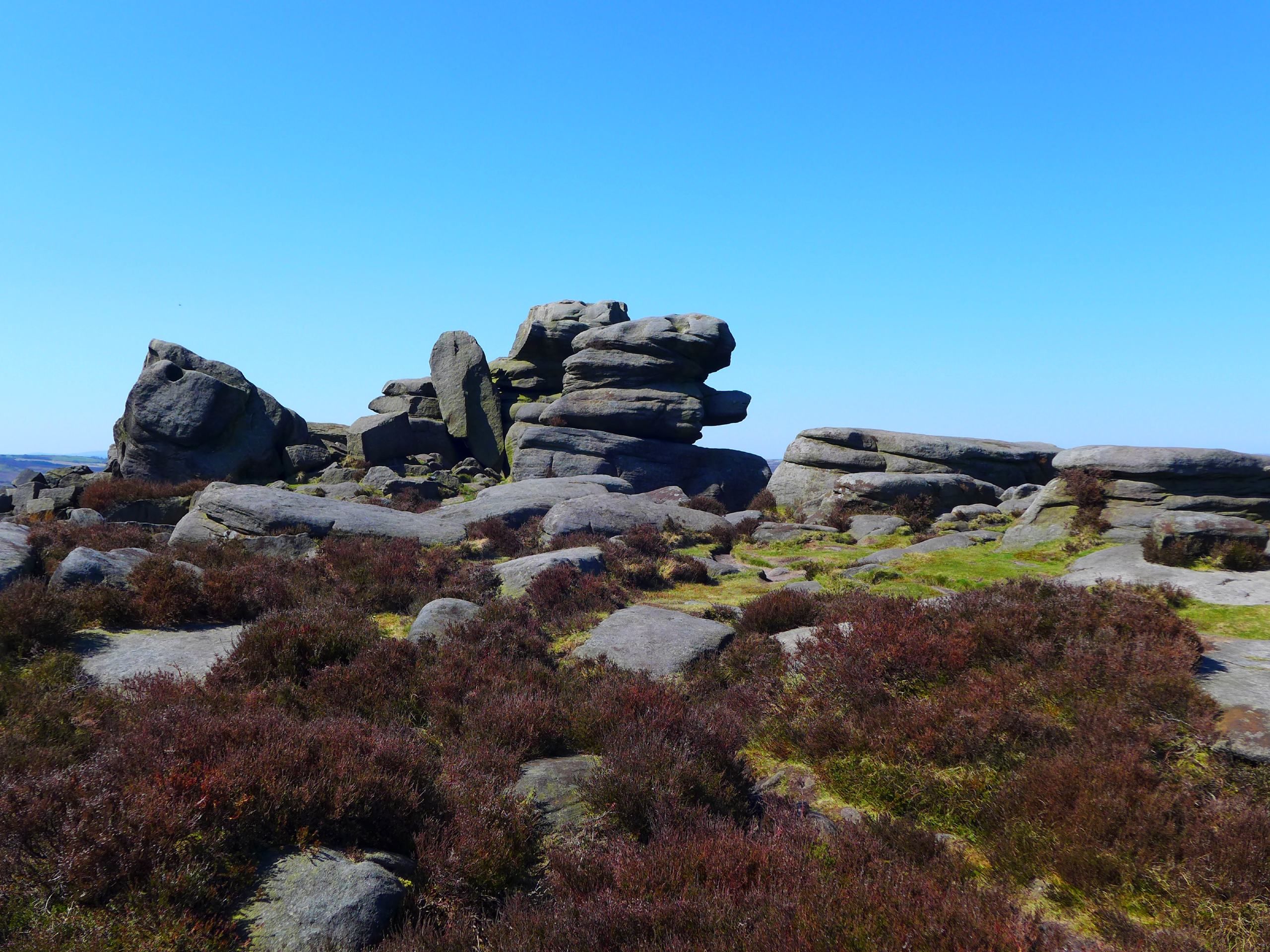
Burbage Edge Woodland Outlook