Rolling coastlines, storybook harbors, and wild moorlands define Devon’s irresistible character for travelers seeking beauty with depth. From fossil-rich Jurassic cliffs to golden surf beaches, the county blends dramatic scenery with centuries of heritage. Food lovers find fresh seafood and cream teas, hikers uncover quiet valleys and ancient tors, while families enjoy welcoming seaside towns. This guide to the most beautiful places in Devon highlights can’t-miss landscapes, hidden gems, and practical visiting insights, helping readers plan unforgettable days filled with coastal light, rolling hills, and timeless English charm across every season of the year for first-time visitors and seasoned explorers.
Woolacombe Beach & Valley Coast
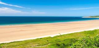
Rolling dunes meet three miles of open Atlantic shoreline along this sweeping stretch of North Devon, where wide sands and powerful surf define the character of the coast. Seasonal lifeguard patrols, consistent wave quality, and expansive walking space make this location equally suited for surfers, families, and long-distance beach walkers. Behind the shoreline, grassy valleys channel coastal winds toward elevated viewpoints, allowing uninterrupted sightlines across Bideford Bay. Wildlife-rich headlands frame the beach, with seabirds frequently visible above the cliffs. Low-tide reveals wide tidal flats, ideal for shoreline exploration and coastal photography. Summer brings steady visitor activity, while off-season months deliver dramatic skies, storm-driven seas, and quiet coastal solitude. Access routes are well maintained, with car parks positioned above the dunes for elevated entry views. The surrounding South West Coast Path connects seamlessly with neighboring headlands, making this stretch a key walking corridor. Local cafés, surf schools, and coastal lodgings support extended stays without disrupting the area’s natural openness. Seasonal light shifts transform the color of both sea and sand throughout the day.
Dartmoor National Park Moorland & Tors

Granite ridgelines rise suddenly from open heather moorland, forming one of southern England’s most distinctive upland landscapes. Weather patterns shift quickly across the plateau, producing fast-moving clouds, mist corridors, and dramatic light contrasts throughout the day. Ancient stone tors punctuate the skyline, each shaped through millennia of erosion and freeze-thaw cycles. Wild ponies roam freely between bog streams, peat flats, and rough grazing fields. Archaeological features appear throughout the terrain, including prehistoric stone rows, hut circles, and medieval tin mining ruins. Narrow lanes thread between villages at the park’s margins, linking market towns and farmland to high open commons. Water sources originate across the moor, feeding rivers that carve deep wooded valleys outward toward the coast. Walking routes follow elevated ridges for long-distance visibility or descend into sheltered combes shaded by oak and birch. Seasonal change dramatically alters ground color and vegetation texture. Rain-darkened stone, frost-coated grasses, and late-summer bracken define shifting visual character. Navigation skills remain essential due to rapidly changing visibility. The combination of scale, isolation, and layered history creates a landscape shaped equally by natural forces and human passage.
Blackpool Sands (South Hams Coast)

Sheltered contours define this crescent-shaped beach along the South Hams coastline, where turquoise water replaces the darker Atlantic tones typical farther north. Shingle replaces sand across most of the shoreline, giving the beach a clean, alpine character rare in southern England. Forested slopes surround the bay on three sides, creating natural wind protection and maintaining warmer surface temperatures during summer months. Kayaking, paddleboarding, and open-water swimming thrive in calmer seasonal conditions. Pebble shelving produces clear underwater visibility near shore, encouraging snorkeling and shoreline exploration. Access remains carefully managed through controlled parking, preserving both water quality and visual appeal. Coastal cafés sit just above the high tide line without dominating views. Walking routes connect the bay to nearby coves and cliff-top pathways linking Stoke Fleming and Dartmouth. Tidal movement remains gentle compared with exposed Atlantic beaches, extending safe family swimming windows. Autumn light intensifies water color clarity, while winter storms reshape the pebble banks with each major swell. Sea grasses and kelp beds fringe the outer edges of the bay. The result remains distinctly Mediterranean in mood despite its unmistakably British setting.
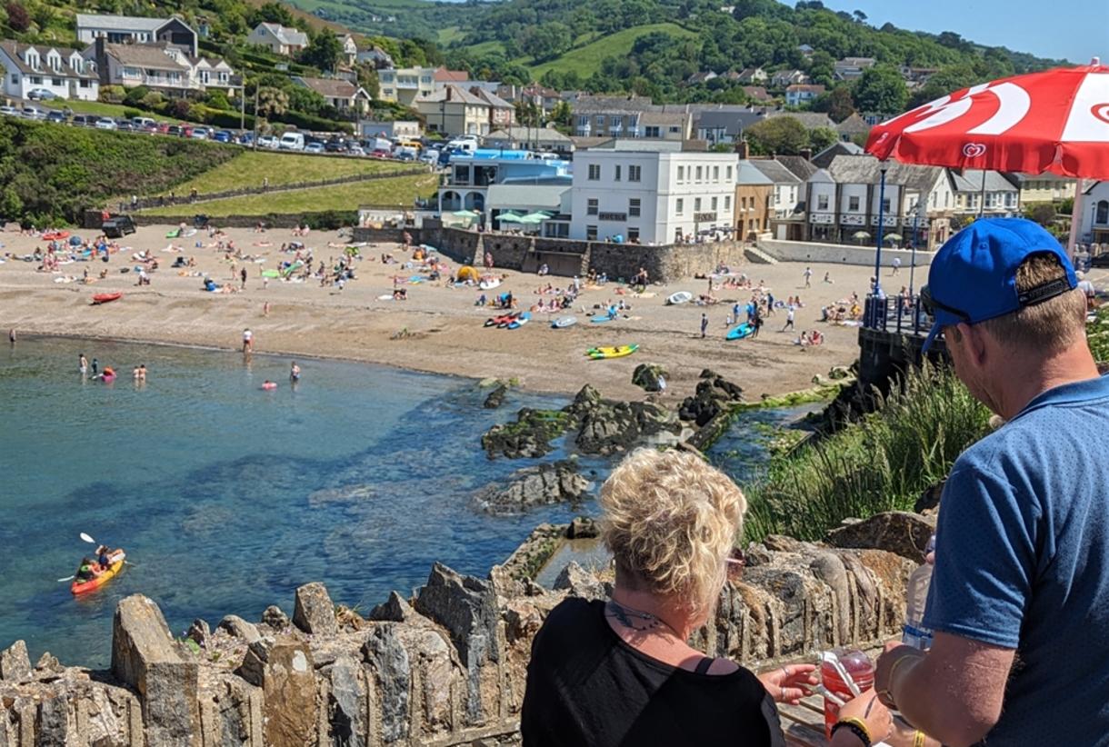
Burgh Island & Bigbury-on-Sea Causeway Coast
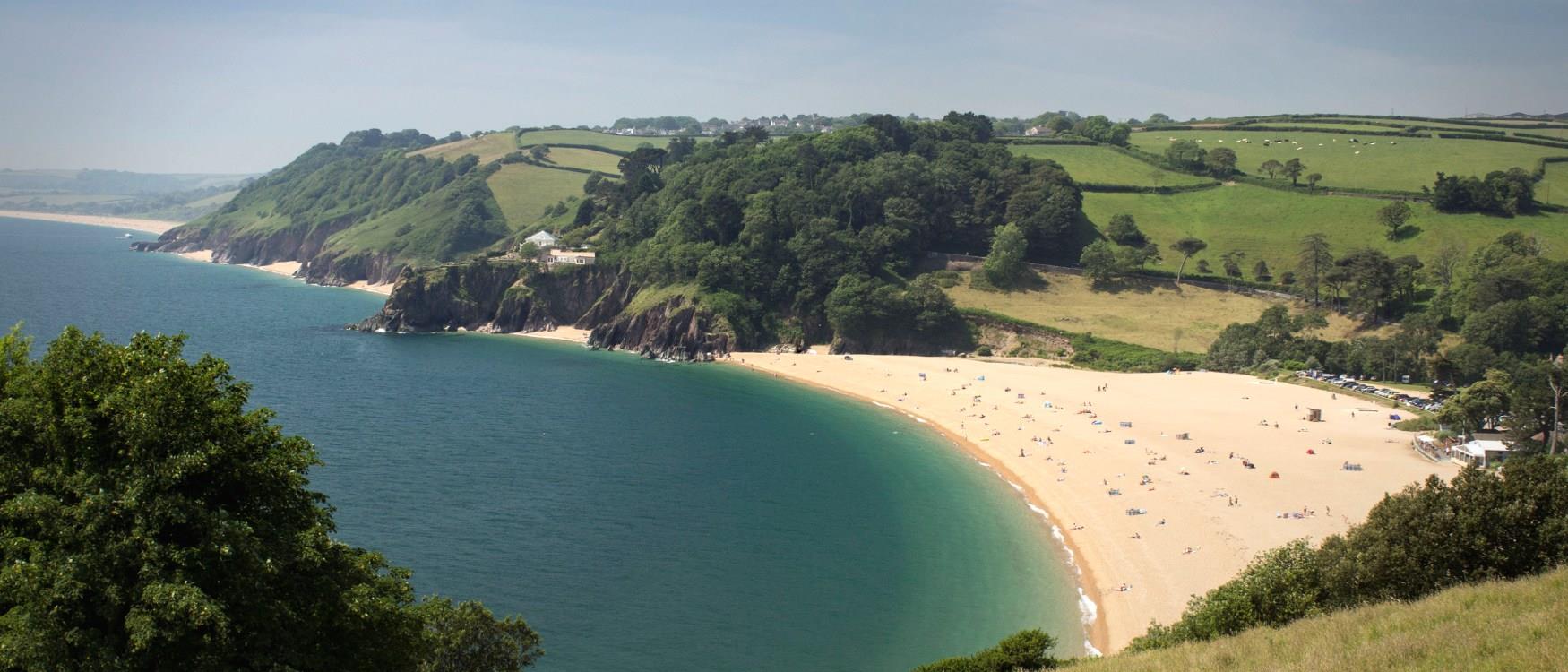
Tidal rhythm defines movement across this celebrated headland reach, where a sand causeway alternately reveals and submerges with each six-hour cycle. Offshore rock formations surround the island, shaping dramatic wave behavior during wind-driven conditions. At low tide, foot traffic crosses directly to the island’s historic summit buildings, while high tide shifts access to sea tractors navigating shallow channels. Beaches extend broadly on both sides of the causeway, offering sheltered paddling on one flank and surf-exposed breaks on the other. Red sandstone cliffs frame the approach with striking color contrast against pale sand and shifting sky. Wildlife regularly appears across the intertidal zones, including seabirds, seals, and migrating waders. Walking routes encircle the island perimeter with open views toward Challaborough and the distant horizon. Light conditions change rapidly as cloud shadows move across the shallow flats. Storm surges sculpt new sand ridges each winter, altering pathways seasonally. Historical associations include smuggling legends and wartime coastal surveillance. Calm summer evenings bring glass-like tidal pools ideal for safe swimming near shore. The interplay of sea, sand, and shifting access creates one of Devon’s most visually kinetic coastal experiences.
Clovelly Cliff-side Fishing Village

Steep grades replace horizontal streets along this privately maintained hillside settlement, where cobbled lanes descend sharply toward a narrow working harbour. Traditional architecture lines both sides of the main pedestrian route, with whitewashed cottages stacked closely along the slope. Wheeled traffic remains impractical by design, preserving original transport methods once reliant on donkeys and sledges. Handlines, lobster pots, and small fishing equipment mark the working maritime heritage still active today. Red sandstone cliffs protect the harbour entrance, while raised terraces provide elevated views across Bideford Bay. Weather exposure becomes immediately apparent through salt-worn stonework and wind-shaped vegetation. Seasonal visitor flow follows the slope top-down, revealing visual layers gradually with each descent. Tide shifts control access to harbour-slip launches and stone quay use. Footpaths extend westward along the clifftops with open grassland exposure and long-distance sea views. Winter brings near isolation, restoring daily routines to residents and fishermen. Museum buildings preserve maritime tools and lifeboat history. The combination of restricted access, preserved layout, and working harbour maintains a rare continuity between landscape, livelihood, and settlement form.
Exe Estuary & Exmouth Coastal Marshlands

Broad tidal channels shape this low-lying wetland system as freshwater flow meets incoming coastal tides. Mudflats expose wide feeding grounds during ebb cycles, drawing migratory birds in large seasonal numbers. Reed beds and salt marsh fringe the estuary edges, stabilizing sediment while supporting diverse insect and plant populations. Cycling routes trace both banks from Topsham to the open sea, offering uninterrupted views across shifting water lines. Sailing clubs, mooring pontoons, and paddle routes operate in protected interior waters away from exposed surf. Sand spits and tidal bars evolve continuously under wind and wave influence. Railway lines trace the eastern margin, following a narrow coastal cut between sea wall and estuarine flats. At the mouth, Exmouth’s long beachfront transitions the estuary into open Channel conditions. Sunlight reflects cleanly across shallow water surfaces during calm tides. Storm events redistribute sediment along the lower banks, reshaping channels gradually. Wader roosts form naturally along submerged spit edges. The estuary remains one of southern England’s most important coastal bird corridors. The blend of active recreation, conservation zones, and fluid tidal movement defines its dynamic coastal identity.
Salcombe & Mill Bay Estuary-to-Sea Scenery

Sheltered turquoise channels wind inland behind opposing headlands, forming one of Devon’s most visually refined estuary environments. Sailing masts, wooded slopes, and sandy inlets create layered depth along the water corridor. Tidal currents remain gentle within the estuary proper, supporting paddlecraft, slow cruising, and shoreline swimming. Across the mouth, Mill Bay opens directly onto open Channel surf conditions with wide pale sand exposures at low tide. Passenger ferries cross the water between town and beach throughout summer. Cliff trails rise sharply above both banks, offering elevated sightlines over merged sea and estuary views. Mediterranean-style planting thrives along sunlit garden terraces. Sandbar formations shift seasonally at the entrance, subtly altering wave behavior and navigation routes. Clear water supports eelgrass beds and small fish populations within the protected inlets. Evening light produces reflective gradients along wooded slopes and anchored vessels. Rolling farmland transitions into deep coastal inlets just beyond the town’s edges. Seasonal weather rarely disrupts boating activity due to the protected anchorage. The resulting contrast between tranquil estuary waters and energetic open sea defines the area’s enduring scenic reputation.
Lee Bay Hidden Cove & North Devon Coast Path
Narrow lanes descend abruptly from open farmland into one of the region’s most concealed coastal pockets. Steep enclosing cliffs restrict visibility from above, revealing the small pebble cove only at final approach. Shallow shelving rock pools form during low tide, harboring anemones, crabs, and sea stars visible in clear conditions. Wave energy concentrates toward the mouth, while interior waters remain calmer for shoreline exploration. Thatched public houses sit near the stream crossing with footbridges linking both sides of the village inlet. The South West Coast Path climbs sharply out of the bay in both directions, producing immediate elevation gains and wide coastal visibility within minutes of departure. Offshore, wave-cut rock platforms emerge during spring tides. Storm debris patterns reveal winter energy long after calmer months return. Limited parking naturally restricts visitor volume. Sunset light reflects strongly off sheltered cove walls. Birdlife nests along upper cliff ledges with frequent aerial activity. The setting rewards restrained development by preserving visual enclosure. The contrast between hidden shoreline and expansive clifftop path creates a striking vertical transition within a short walking distance.
Bovisand & Plymouth Sound Coastal Cliffs
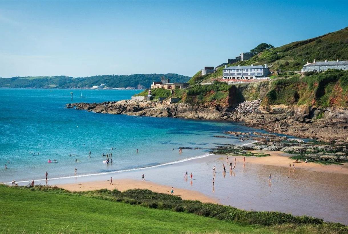
Protected waters define this eastern Sound shoreline, where sheltered coves replace direct Atlantic exposure. Shelving beaches alternate between shingle and sand along short intervals of headland and inlet. Submerged rock ledges create favored diving and snorkeling zones with historically documented wreck sites offshore. Coastal batteries and defensive ruins appear across cliff terraces, reflecting the strategic naval significance of the surrounding waters. Sail traffic remains constant across sheltered anchorages year-round. Cliff paths thread through mixed woodland and exposed grass slopes, offering open views toward Drake’s Island and distant Dartmoor ridgelines on clear days. Water colors remain unusually clear due to reduced sediment disturbance compared with open surf coasts. Seasonal kelp growth supports localized fish populations near rock shelves. Sunrise light reflects strongly across east-facing cliff faces. Military heritage blends into natural slope stabilization. Winter storms affect outer Sound channels while inner bays remain comparatively calm. The result creates year-round marine access conditions suitable for paddlecraft, sailing, and cold-water swimming. Urban proximity never overwhelms the coastal character. The balance between historical defense structures and active marine recreation defines this quietly dramatic stretch of coastline.
Torbay & English Riviera Harbour Towns

Curved headlands form a sheltered amphitheater of maritime towns encircling one of the south coast’s most protected bays. Palm-lined promenades, marinas, and working fishing harbours share the shoreline with Victorian-era terraces rising above the water. Torquay, Paignton, and Brixham each contribute distinct harbor identities within a compact marine setting. Cliff-backed beaches alternate with pier-fronted town fronts around the bay perimeter. Mild microclimate influence supports subtropical plant growth uncommon at this latitude. Ferry movements, leisure craft, and commercial fishing operate in close proximity under calm tidal conditions. Elevated viewpoints along the surrounding hills reveal full bay curvature in clear weather. Coastal rail lines cut through red sandstone cliffs beneath residential terraces. Sunrise and evening light sweep evenly across the enclosed water surface. Limestone geology dominates inland ridges and cave systems below sea level. Seasonal tourism never fully disrupts daily harbor trade activity. Winter storms rarely penetrate the bay with significant force. The consistent shelter and compact maritime scale explain the region’s long-standing identity as England’s Riviera coastline.
Combe Martin / North Devon Coastal-Hillscape
Sharp valley walls funnel inland toward rolling upland ridges beyond the narrow sheltered harbor. Exposed cliff systems rise abruptly from deep water, creating vertical contrast between marine access and elevated pasture. Shingle beaches dominate the shoreline with shifting storm berms along the tidal edge. Sea caves and natural arches cut into resistant rock faces across the outer headlands. Footpaths climb steeply toward ridge-top fields where panoramic views extend both across the Bristol Channel and inland toward Exmoor’s fringes. Historical silver mining left adits and spoil lines scattered above the settlement. Bright stream flows enter the bay after rainfall, briefly altering water clarity. Wave reflection off opposing cliffs produces complex rebound patterns within the narrow inlet. Offshore currents concentrate plankton and seabird activity near the point. Farmland patterns extend close to the cliff tops without visual interruption. Sunrise light reaches the valley later due to cliff shadowing, while sunsets linger through west-facing horizons. The combination of deep valley form, exposed headlands, and upland proximity defines the dramatic compressed terrain character of this coastal settlement.
South Devon Jurassic Coast Cliffs & Bays

Layered sedimentary rock reveals millions of years of marine deposition along this geologically complex coastline. Red sandstone transitions into limestone and shale formations across successive headlands and bays. Cliff falls regularly expose fossil-bearing strata after winter storms. Storm beaches of cobble and shingle form beneath steep rock faces where wave energy disperses. Offshore stacks and eroded platforms indicate long-term coastal retreat. Vegetation zones shift with cliff exposure, supporting wildflowers on sheltered slopes and salt-tolerant grasses along exposed edges. Footpaths trace unstable margins with seasonal rerouting as erosion progresses. Fishing villages occupy natural breach points where valleys cut through the cliff system. Wave refraction patterns vary sharply across contrasting rock hardness. Sea caves expand gradually year by year under hydraulic pressure. Tide pools form across stepped rock shelves at low water. The visible stratification illustrates ancient climate cycles and oceanic change preserved in stone. Coastal research emphasizes the region’s importance for paleontological study. The ongoing interaction of erosion, wave energy, and time continues reshaping every visible surface along this geologically active coastline.