England’s cities preserve layers of Roman, medieval, and industrial heritage within walkable streets and living neighborhoods. This guide focuses on destinations where history remains tangible through architecture, museums, and long-established traditions. Readers gain practical insight into which cities best suit short visits, cultural breaks, or deeper exploration, alongside context on transport links and seasonal timing. Clear planning advice supports efficient itineraries that balance landmarks with everyday character. Ideal for first-time visitors and return travelers, the content helps identify places offering genuine historical depth rather than surface-level sightseeing, ensuring each stop delivers meaningful perspective on England’s evolving story and enduring urban identity.
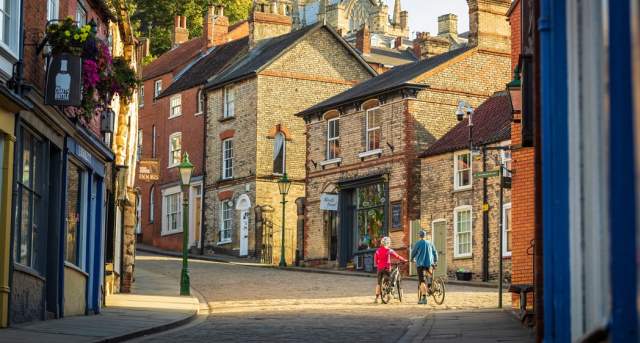
York’s Medieval Streets & Hidden Snickelways
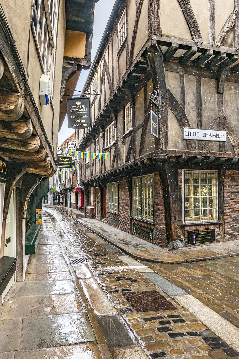
Cobblestone lanes curve tightly through England’s best-preserved medieval city, revealing centuries of layered history within compact walking distances. York’s snickelways—narrow pedestrian passages threading between timbered buildings—once served merchants, monks, and market traders moving unseen across the city. Routes such as Whip-Ma-Whop-Ma-Gate and Nether Hornpot Lane still feel unchanged, leading quietly from busy streets to secluded corners. The Shambles stands out with its overhanging fifteenth-century shopfronts, originally designed to protect butcher stalls from sun and rain. Beyond the postcard views, fragments of Roman walls, Viking street patterns, and medieval guild halls remain embedded in everyday routes. Walking the perimeter walls provides elevated perspectives over church spires, gardens, and rooftops before dropping back into intimate lanes below. Hidden courtyards near Petergate reveal stone façades linked to York Minster’s long ecclesiastical influence. Even modern cafés occupy buildings shaped by medieval footprints. Compact scale makes exploration manageable without transport, while signage explains historic transitions clearly. These streets reward slow wandering, offering constant visual shifts between open squares and shadowed alleys, making York a practical and atmospheric starting point for understanding England’s urban medieval heritage.
Bath’s Georgian Crescents & Thermal Heritage

Honey-colored stone defines this UNESCO-listed city, where eighteenth-century planning transformed natural hot springs into an elegant urban landscape. Bath’s Georgian crescents—Royal Crescent and The Circus foremost among them—display symmetrical façades designed to project order, refinement, and social status. These curved terraces overlook green spaces intended for promenade culture, blending architecture with leisure. Beneath the polished surface lies a far older tradition: Britain’s only naturally occurring thermal waters. Roman engineers first formalized bathing here, constructing complex pools and temples whose remains still sit at the city’s core. The continuity between Roman foundations and Georgian refinement gives Bath its distinctive historical depth. Walking routes connect sweeping viewpoints with intimate courtyards, revealing how architects used uniform stonework to unify the city visually. Museums, assembly rooms, and pump houses illustrate how spa culture shaped social life, from health rituals to elite gatherings. Views from Bathwick Hill and Prior Park highlight the city’s harmony with surrounding countryside. Everything remains walkable, making orientation simple. Bath offers a clear example of how natural resources, classical ideals, and urban planning merged to create one of England’s most cohesive historic cities.
Oxford’s College Quads & Storybook Lanes

Stone colleges sit behind archways that open suddenly onto enclosed quadrangles, creating a rhythm of discovery throughout this academic city. Oxford’s historic core operates as a collection of independent institutions, each with its own chapel, dining hall, and courtyard. Medieval lanes such as Catte Street and Broad Street connect these spaces, forming routes shaped more by centuries of foot traffic than modern planning. Architectural styles shift subtly from Norman to Gothic to Baroque, often within a single walk. Bodleian Library landmarks anchor the city visually, while quieter passages near Merton and Corpus Christi offer a calmer atmosphere. College gardens, visible through iron gates, soften the dense stone environment. Punts drift along the Cherwell and Thames, adding open riverside perspectives that contrast with tight alleyways. Literary associations—linked to figures like Lewis Carroll and J.R.R. Tolkien—enhance the city’s narrative appeal. Despite its global academic reputation, Oxford remains navigable on foot, with clear signposting and public access to many historic interiors. The balance between scholarly function and preserved urban form makes Oxford both intellectually and visually immersive, offering visitors layered insight into England’s educational and architectural traditions.
Cambridge’s Riverside Courts & Punting Backdrops
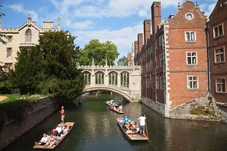
Reflections of limestone colleges ripple across the River Cam, defining the visual identity of this compact scholarly city. Cambridge’s riverside courts align closely with the water, creating open sightlines framed by bridges, lawns, and chapel towers. Punting routes glide past King’s College Chapel, Trinity College, and St John’s, offering perspectives inaccessible from streets. Away from the river, narrow lanes such as Trinity Lane and Green Street connect courtyards that evolved organically rather than through formal planning. Gothic fan vaulting, Tudor brickwork, and later classical additions coexist without visual clutter. College backs provide generous green buffers, reinforcing a sense of calm despite the city’s central location. Pedestrian bridges act as scenic connectors, each contributing a different architectural style. Market Square introduces contrast, bringing daily trade into the historic core much as it has for centuries. Museums and libraries remain integrated rather than isolated, supporting continuous foot exploration. Compact distances allow visitors to combine riverside views with inner courts easily. Cambridge’s appeal lies in its clarity—history remains legible, spaces remain functional, and the river continues to shape both movement and atmosphere.
Canterbury’s Cathedral Precincts & Medieval Shops
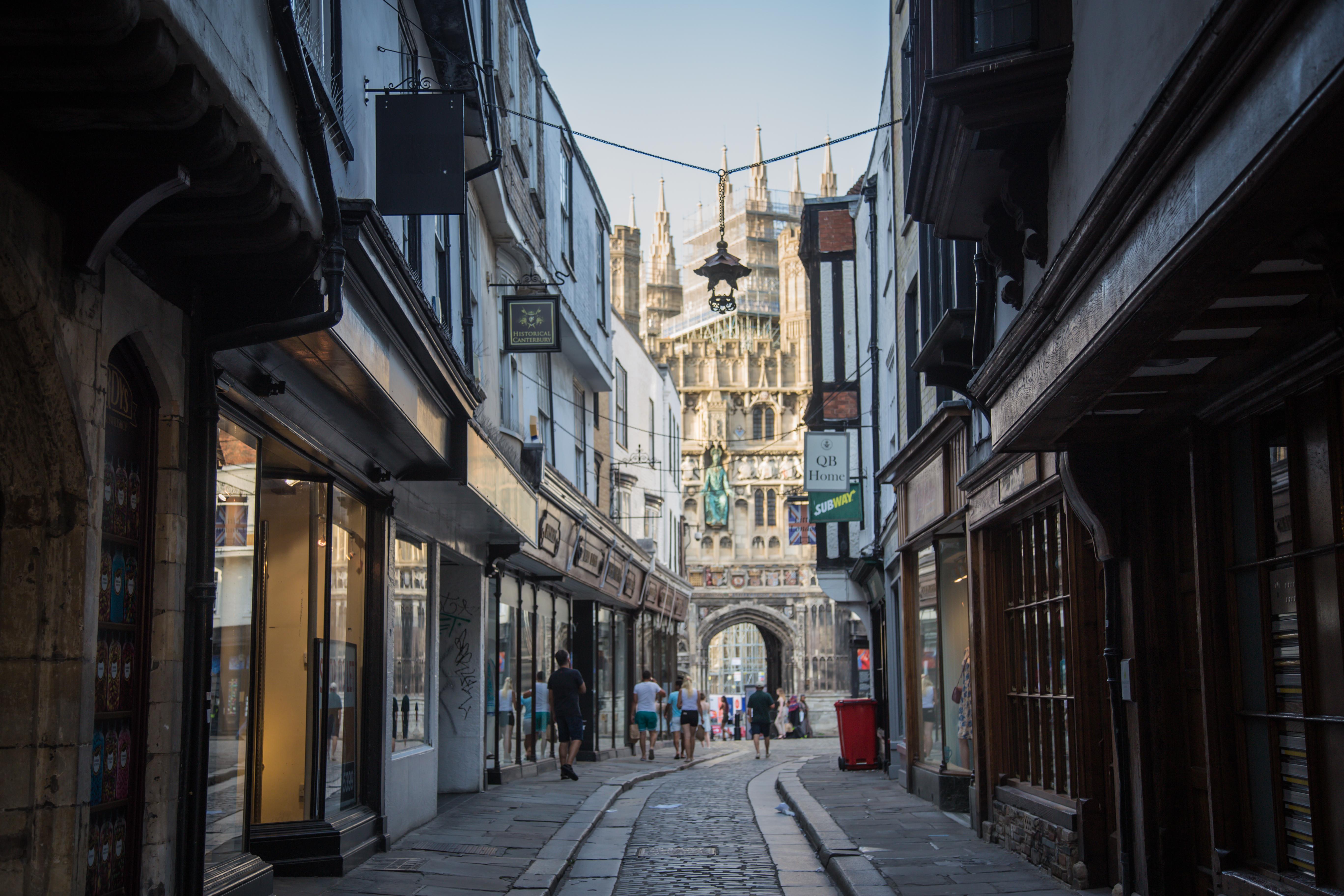
Pilgrimage routes once converged here, shaping a city organized around spiritual and commercial exchange. Canterbury Cathedral dominates the skyline, its precincts forming a contained historical district separated subtly from surrounding streets. Approaching through Mercery Lane reveals timber-framed shops originally catering to medieval pilgrims, many still occupied by independent traders. Stone gateways mark transitions between civic life and ecclesiastical calm. Within the cathedral grounds, cloisters and gardens reflect centuries of religious authority and craftsmanship. Roman remnants beneath street level hint at even earlier foundations, reinforcing Canterbury’s long continuity. The River Stour loops through the city, adding bridges and waterside walks that soften the urban density. Museums explain the city’s role in England’s religious history, including connections to Thomas Becket and the Reformation. Streets remain narrow, guiding visitors naturally toward the cathedral without signage overload. Public access routes respect the precinct’s historic boundaries while remaining welcoming. Canterbury succeeds as a living city rather than a static monument, where medieval layouts support modern movement and commerce. This balance allows visitors to understand how faith, trade, and daily life intersected within one of England’s most influential historic centers.
Durham’s Castle-Cathedral Hilltop Walks
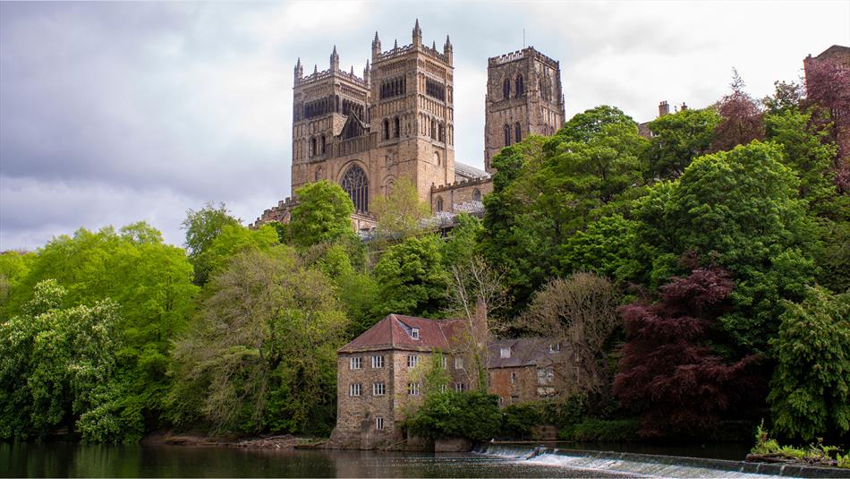
A dramatic peninsula carved by the River Wear sets the stage for one of England’s most striking historic ensembles. Durham’s cathedral and castle rise together on elevated ground, forming a fortified silhouette visible from surrounding woodland paths. Approaches along river loops gradually reveal the scale of Norman architecture, emphasizing strategic placement rather than decorative excess. Narrow streets climb toward Palace Green, where open space contrasts with dense stonework. The castle, now part of the university, illustrates adaptive reuse while retaining medieval form. Views from Prebends Bridge and Framwellgate Bridge frame the hilltop structures against natural slopes, reinforcing the city’s defensive origins. Inside the cathedral, massive columns and vaulted ceilings demonstrate early Romanesque engineering. Walking routes encircle the peninsula, offering varied elevations and viewpoints within short distances. Despite its monumental appearance, Durham remains compact and navigable, with clear pedestrian access throughout the historic core. The surrounding university colleges integrate into older buildings without overwhelming them. Durham’s setting highlights how geography influenced medieval urban design, making it an essential example of how landscape and architecture combined to project authority and permanence.
Lincoln’s Steep Hill & Gothic Landmark Corners
Gradient defines the experience of this historic city, where physical ascent mirrors historical progression. Steep Hill rises sharply from the lower town to Lincoln Cathedral, once the tallest building in the world. This climb passes medieval houses, guild halls, and stone archways that compress and release space dramatically. The upper city reveals expansive views across Lincolnshire, emphasizing the cathedral’s dominance. Gothic detailing, flying buttresses, and stained glass mark the culmination of centuries of ecclesiastical ambition. Roman origins remain visible at Newport Arch, one of the best-preserved Roman gateways in Britain, anchoring the city’s timeline. Streets curve around elevation changes rather than resisting them, preserving organic movement patterns. Independent shops occupy historic structures, keeping the route active and relevant. Castle walls nearby offer alternative viewpoints and quieter walking loops. Despite the demanding incline, benches and rest points support slower exploration. Lincoln’s vertical layout provides clarity—each stage reflects a different era, making the city especially effective for understanding how power, faith, and trade shaped urban form over time.
Chester’s Roman Walls & Two-Level Tudor Rows
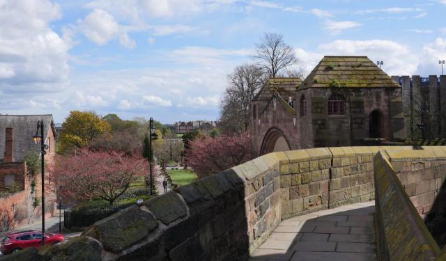
Encircling walls offer uninterrupted walking routes above street level, defining this city’s unique structure. Chester’s Roman walls remain largely intact, providing elevated perspectives over the River Dee, cathedral precincts, and medieval streets. Below, the Rows introduce an unusual two-level shopping system, where covered walkways sit above ground-floor units. Timber-framed façades line these galleries, creating continuity between commerce and architecture. Roman foundations, medieval extensions, and Tudor adaptations coexist visibly, making historical transitions easy to follow. Gates punctuate the walls, marking ancient entry points that still direct traffic today. The amphitheatre near the city center reinforces Chester’s Roman identity, while riverside paths offer calmer alternatives to the busy core. Compact scale supports full exploration on foot within hours. Clear interpretation boards assist understanding without disrupting movement. Chester’s layered design demonstrates practical adaptation rather than replacement, showing how historic infrastructure can remain functional. This combination of defensive planning and commercial innovation distinguishes Chester from other English cities, offering a clear case study in long-term urban continuity.
Winchester’s Cathedral Quarter & Riverside Paths
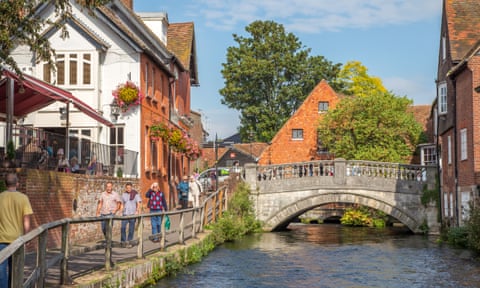
Formerly England’s capital, this city retains quiet authority through its spatial layout rather than monumental scale. Winchester Cathedral stretches lengthwise across the historic core, guiding movement along its precincts and surrounding streets. The close blends ecclesiastical buildings with residential lanes, maintaining a lived-in atmosphere. Medieval alleyways connect to open green spaces beside the River Itchen, where water meadows and footpaths soften the urban edge. These riverside routes were once essential for milling and transport, remnants of which remain visible. Norman and Gothic elements define the cathedral interior, while nearby Wolvesey Castle ruins reference early royal power. Signposted heritage trails link Alfred the Great’s legacy with later religious developments. Streets remain manageable, encouraging walking without congestion. Bookshops, cafés, and small museums occupy historic structures without overwhelming them. Winchester’s appeal lies in restraint—history is present but not overbearing. The relationship between sacred space, civic life, and natural waterways offers insight into how early English capitals balanced governance, faith, and daily movement.
Salisbury’s Spire Views & Cathedral Close Meadows

Open land surrounds one of England’s most visually distinctive cathedrals, emphasizing scale through contrast rather than density. Salisbury Cathedral’s spire rises from expansive water meadows, visible from multiple approach routes across the city. The surrounding close forms a planned precinct of historic houses, schools, and lawns arranged with deliberate spacing. Streets leading inward narrow gradually, enhancing the reveal of the cathedral façade. Medieval planning here favored separation from commercial clutter, resulting in unusually open surroundings. Walking paths trace the River Avon, linking bridges, gardens, and grazing land that still floods seasonally. The cathedral interior houses the best-preserved original Magna Carta, grounding visual grandeur in political history. Town streets beyond the close remain modest, lined with market buildings and independent shops. Distances are short, supporting relaxed exploration without transport. Salisbury’s design demonstrates intentional medieval urban planning, where spiritual focus dictated spatial hierarchy. This clarity makes the city particularly accessible for understanding how religious priorities shaped English town development.
Norwich’s Lanes, Market, & Riverside Cathedral Views

Street patterns here reveal a once-powerful medieval trading center shaped by wool, waterways, and religion. Norwich’s lanes twist tightly around one of England’s oldest open-air markets, which still operates daily. Timber-framed buildings line routes that once linked merchants to river ports along the Wensum. The cathedral rises from a broad precinct separated from commercial bustle, its Norman tower visible across rooftops and riverside paths. Bridges connect residential quarters, maintaining historic movement patterns. Elm Hill offers one of the city’s most intact medieval streets, preserved through careful conservation. Churches appear frequently, reflecting Norwich’s former status as England’s second city. Riverside walks provide quieter perspectives and reveal former industrial uses now adapted for leisure. Despite its size, the historic core remains navigable, with signage supporting independent exploration. Norwich balances density with openness, preserving trade-driven urban form alongside spiritual landmarks. The result is a city where medieval life remains readable, offering practical insight into how commerce shaped English urban history.
Exeter’s Quayside & Underground Passages

Trade routes shaped this southwestern city from Roman foundations through medieval expansion. Exeter’s quayside developed as a working port along the River Exe, with warehouses, canals, and towpaths supporting regional commerce. Walking routes here remain flat and accessible, contrasting with the elevated cathedral quarter above. Beneath the streets lies a hidden network of medieval underground passages, originally built to protect the city’s water supply. Guided access reveals vaulted tunnels that illustrate early engineering responses to siege and sanitation threats. Above ground, narrow lanes climb toward the cathedral, passing fragments of Roman walls and Saxon foundations. The cathedral’s twin towers define the skyline, anchoring the historic center visually. Independent shops and cafés occupy former trade buildings, maintaining continuity of use. Riverside paths connect to longer cycling and walking trails, extending exploration beyond the core. Exeter’s layered infrastructure—visible and concealed—offers a rare opportunity to understand how functional needs shaped urban development. This combination of river commerce, defensive planning, and religious influence makes Exeter a distinct and instructive historic city.