Snow-dusted peaks, ancient caravan routes, and villages untouched by time—few journeys rival the raw grandeur of the Pamir Highway. Winding through Tajikistan’s remote highlands, this legendary road trip offers more than just altitude; it delivers cultural immersion, Soviet history, and landscapes that defy expectation. Often called “The Roof of the World,” the route tests endurance while rewarding travelers with unmatched views and authentic encounters. For those drawn to untamed frontiers and soul-stirring scenery, this guide reveals how to tackle one of Earth’s most exhilarating road trips safely and meaningfully, ensuring every mile brings both adventure and understanding.
Dushanbe Electronic GBAO Permit Pickup

Visitors planning a Pamir Highway journey must secure the GBAO permit, and Dushanbe now offers a digital system that simplifies the process. The electronic General Permit for Autonomous Oblast (GBAO) is a crucial travel document required for entering Tajikistan’s eastern regions, including the rugged Gorno-Badakhshan province. The permit can be applied for online through the Tajik e-visa portal, with approval typically processed within 48 hours. Upon arrival, travelers are advised to confirm their documentation at the designated immigration desks inside Dushanbe International Airport or at local OVIR offices in the city. Carrying both a printed and digital copy ensures smoother checkpoint crossings along the Pamir route. Delays can occur if submitted photos or passport scans are unclear, so high-quality uploads are essential. For those beginning their drive from Dushanbe, verifying the GBAO endorsement before departure avoids any roadblock refusals in remote stretches. This digital permit system has significantly reduced bureaucratic friction for overlanders and cyclists traveling through the High Pamirs. Government efforts to digitize access reflect the region’s growing popularity among international adventurers. This is your passport to the Roof of the World—one that unlocks dramatic high-altitude landscapes, ancient Silk Road trails, and culturally rich villages of the Pamir Mountains.
Kulob Fuel & SIM Station

Travelers heading south from Dushanbe often plan their final major refuel in Kulob, a city known for its strategic location at the edge of the Pamir Highway route. Gas stations in Kulob are typically better stocked than those in eastern settlements, offering higher-grade petrol and diesel that’s critical before crossing into less serviced terrain. It’s wise to top off both the tank and reserve jerry cans, as fuel scarcity becomes an increasing concern the deeper one ventures into the highlands. Kulob is also one of the last convenient points for purchasing a local SIM card with reliable 4G coverage. Providers like Tcell or MegaFon operate small kiosks where foreign travelers can register with a passport and select prepaid data bundles suited for multi-day trips. Once outside Kulob, signal strength diminishes drastically, with only occasional reception near larger towns like Khorog or Murghab. Stocking up on airtime, internet, and power bank backups ensures smoother communication in emergencies or navigation. Kulob’s dual utility—fuel for the engine and SIMs for connectivity—makes it an essential prep stop before tackling the dramatic switchbacks and barren plateaus of the Pamirs. Every kilometer past Kulob gets lonelier, so prepping here means traveling smarter.
Qalai-Khumb Riverside Homestay

Nestled at the confluence of two mountain rivers, Qalai-Khumb offers a serene midpoint rest between Dushanbe and Khorog. This small settlement is a key overnight stop for Pamir Highway travelers, particularly those seeking hospitality and authentic cultural immersion. Riverside homestays here provide more than basic shelter—they offer home-cooked plov, local mulberry jam, and the warmth of traditional Pamiri family life. Rooms often include patterned suzani textiles and wood-carved interiors, offering a rustic yet welcoming ambiance. With limited formal hotels in the region, homestays become lifelines—especially for cyclists, overlanders, and trekkers tackling the winding roads along the Panj River. Electricity is intermittent, so it’s smart to bring a charged power bank and flashlight. Many homestays also share access to solar-powered showers or communal outdoor taps, ideal for refreshing after a long dusty ride. Beyond comfort, Qalai-Khumb is a vital spot for road condition updates and local weather insights—often passed from traveler to traveler over tea. Booking in advance isn’t always necessary but checking for vacancies during peak summer months can help secure better amenities. This riverside pause grounds you in the pulse of Pamir life and gently introduces the endurance required for the road ahead.
Wakhan Valley Hot-Spring Excursion
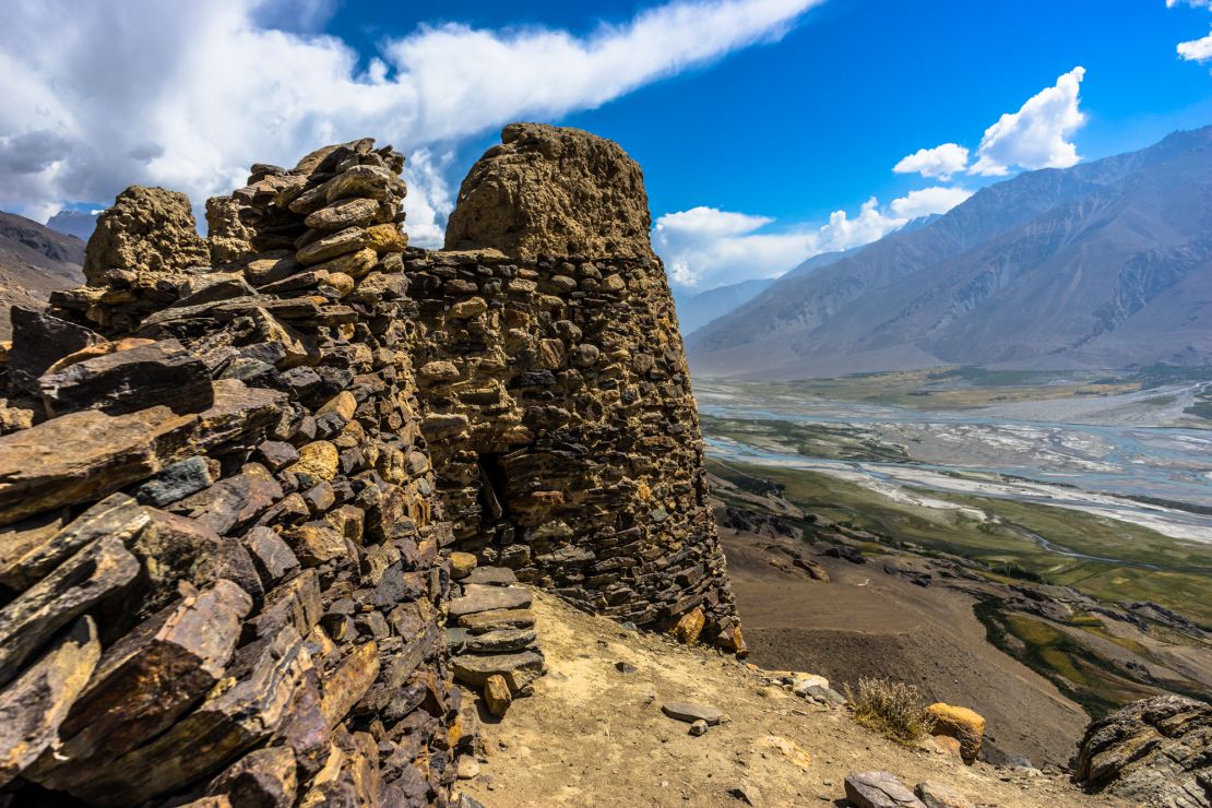
Soaking in a natural hot spring while snow-capped peaks rise above is a rare indulgence—and that’s exactly what the Wakhan Valley delivers. As the highway turns south from Khorog, the detour through the Wakhan Corridor reveals not just scenic drama but geothermal marvels like Bibi Fatima and Garm Chashma. These mineral-rich hot springs are revered locally for their healing properties, with separate bathing areas for men and women. Bibi Fatima, perched on a rocky slope near Yamchun Fortress, offers panoramic views and sulfuric steam that seeps from deep tectonic fractures. Travelers often time their visit to coincide with sunset, when the light washes over the Afghan mountains just across the Panj River. While facilities are basic—concrete tubs and stone enclosures—there’s undeniable magic in this remote wellness ritual. Entry fees are minimal, and some sites even include homestay options nearby for overnight stays. The roads leading to these springs are narrow and rugged, so high-clearance vehicles are recommended. Bathing etiquette requires modesty, with swimsuits or wrap towels preferred. This geothermal break is more than a spa—it’s a cultural and elemental immersion, connecting body and landscape along one of the most remote inhabited valleys on Earth.
Murghab Monday Yak Market

Each Monday morning, Murghab transforms from a quiet highland outpost into a vibrant exchange hub as yak herders, merchants, and nomads gather for the weekly market. Located at over 3,600 meters elevation, this bazaar is one of the highest-altitude markets in Central Asia and offers an unfiltered window into high Pamiri life. Locals arrive from surrounding plateaus with livestock, wool, dried herbs, and handmade felt crafts. The yak trade takes center stage—these hardy animals serve as transportation, currency, and food source in this sparse terrain. Prices fluctuate seasonally, and bargaining is expected. While most goods cater to local needs, travelers can find unique souvenirs like hand-woven kalpaks or fermented yak milk in recycled bottles. Photography is permitted, though it’s polite to ask, especially when capturing close-ups of traders or animals. Don’t expect signage or set hours—things start early and wind down by midday. Bringing small notes in Tajik somoni helps with transactions. This market isn’t designed for tourists, which is exactly why it’s worth the detour. It’s a living reminder that life on the Pamirs isn’t just remote—it’s resilient, rhythmic, and deeply communal. Mondays in Murghab pulse with that hardy mountain spirit.
Ak-Baital Pass Altitude Pause

Crossing Ak-Baital Pass delivers a rare encounter with extreme elevation—standing at 4,655 meters, it’s the highest navigable road in the former Soviet Union. This windswept stretch of the Pamir Highway marks the true “Roof of the World” and tests both machinery and biology. Vehicles may struggle in the thin air, so it’s wise to drive slowly and avoid overloading engines. Travelers often stop here briefly to acclimatize and snap panoramic shots of jagged peaks and lunar-like plains. The terrain is barren yet majestic, with ice patches lingering even in July. Altitude sickness symptoms—headache, nausea, shortness of breath—can strike suddenly, so hydrating and resting beforehand is key. Some visitors bring Diamox or chew dried apricots to ease adjustment. While there’s no infrastructure or shops, Ak-Baital remains a symbolic milestone for overlanders, cyclists, and motorbikers alike. Wind gusts are harsh, so layers and gloves are non-negotiable. It’s also one of the few points where GPS and satellite communicators have better chances of syncing. At this altitude, you’re not just driving across a mountain pass—you’re threading through a high-altitude frontier shaped by tectonic force, solitude, and the raw, rugged defiance of nature.
Karakul Dawn Lake Camp

Witnessing daybreak at Karakul Lake is a reward few forget. Situated at over 3,900 meters above sea level, this saltwater lake formed by a meteor impact stuns with its alien beauty—deep turquoise waters framed by snowy ridgelines. Many travelers set up camp along its northern shore to catch the pinks and purples of sunrise dancing on the water. The air is razor-sharp and cold even in summer, so layering up before crawling out of your tent is essential. Most campsites are primitive—expect no plumbing or marked fire pits, just nature at its starkest. Still, travelers value this spot for its quiet solitude and surreal reflection shots. Karakul village nearby has a few homestays and stores offering basic provisions like bread, eggs, and powdered milk. Campers should carry out all trash and avoid leaving food out—foxes occasionally raid tents. For photographers, a wide-angle lens and polarizer bring out the lake’s mirrored depth. Local children often greet travelers with curiosity, and it’s customary to offer a small gift or photo print in return. Karakul isn’t just another stop—it’s a high-altitude dreamscape that slows time and sharpens the senses.
Polarizer Filter Glacial Shots

Snapping high-altitude lake or glacier photos on the Pamir Highway becomes dramatically easier with a circular polarizer filter. Harsh midday sunlight and high UV exposure often lead to washed-out skies and overexposed water surfaces. A polarizer helps cut glare and deepen blues, revealing crisp glacier details, striations, and textures invisible to the naked eye. This accessory is particularly effective at Karakul Lake, Rangkul, and along icy patches past Ak-Baital Pass. For smartphones, clip-on polarizers are cheap and portable, offering significant improvements without adding bulk to your kit. Adjusting the filter’s rotation while framing the shot lets you fine-tune reflections on water or glassy terrain. Glaciers become more textured, skies more dramatic, and snowfields more dimensional. It’s also handy for photographing yaks or livestock near reflective riverbanks, where glare can ruin close-ups. Cold batteries are a known issue here, so always keep spares close to your body to maintain charge. Photos taken without glare often appear more professional, and for travel bloggers or content creators, this one tool elevates visual storytelling across social platforms. One simple filter can turn a blurry memory into a hero image worth sharing and saving.
Roof-Mounted Solar Power Hub

Maintaining power on the road across the Pamirs is a challenge, especially with extended stretches between towns. Roof-mounted solar panels have become a go-to solution for overlanders and long-distance bikers tackling this electricity-scarce route. Compact 100W or 200W panels installed on car roofs or bike trailers offer a reliable way to charge cameras, phones, laptops, and satellite devices. With clear skies and high solar exposure, efficiency remains high even on overcast days at altitude. Lithium-ion power stations paired with solar panels can hold a full day’s charge and distribute power through multiple ports—perfect for running a small fridge, drone charger, or water purifier. Panels should be secured with adjustable brackets to avoid movement on bumpy roads, especially the rough gravel past Murghab. For motorcyclists, foldable solar mats serve as a lightweight, stowable option. Locals may look on with curiosity, often asking about the setup—a good opportunity for cultural exchange. Having your own power source means fewer dependency points and added safety in remote zones where gas stations may have no electricity or backup. In this part of the world, self-sufficiency isn’t a luxury—it’s the standard.
Reopened Tajik–Kyrgyz Border Loop

For years, geopolitical tensions had sealed off key border crossings between Tajikistan and Kyrgyzstan, complicating loop itineraries for overland travelers. Recently, the Kyzyl-Art Pass route reopened, offering renewed access between Murghab and Sary-Tash. This reopening marks a major logistical win for those looping through the Pamir Highway and continuing north toward Osh or south from Kyrgyzstan into Tajikistan. Border formalities remain strict but efficient—expect inspection of GBAO permits, vehicle documents, and customs checks. Travelers should arrive early, as crossings close by late afternoon and queues can be unpredictable. While the route is gravel-heavy, it rewards with stark views of Lenin Peak and sweeping glacial valleys. Money changers may be absent, so carry small notes in both currencies. Once inside Kyrgyzstan, roads improve dramatically, and mobile reception returns. This route is ideal for those seeking to exit the Pamir loop via a less trafficked and dramatically scenic corridor. For cyclists and motorbikers, this reopening slashes days off the return journey. Planning ahead for fuel, water, and border-specific rules minimizes delays. Reconnecting these two highland nations via this remote pass reopens more than a border—it rekindles an iconic Silk Road link.
Night‑Sky Timelapse by Karasu

Astrophotography lovers will find Karasu one of the most rewarding locations for night-sky timelapse captures. Nestled in a remote valley with near-zero light pollution, this barren stretch north of Murghab is known for its pitch-black skies and stargazing clarity. On moonless nights, the Milky Way blazes across the horizon, accompanied by distant silhouettes of the Trans-Alai Range. Setting up a tripod here allows for hours-long exposures of celestial movement, satellite trails, or meteor showers. Time-lapse settings with intervalometers or apps like PhotoPills are commonly used to automate hundreds of frames for stitched sequences. Bring extra batteries, as cold can drain power quickly. A wide-angle lens with f/2.8 or wider aperture yields the best results. While there’s no lodging nearby, car camping or tent setups are popular among self-sufficient travelers. Watching constellations swirl above this frozen plateau can be both a visual triumph and a grounding moment amid a long expedition. For creators or hobbyists, Karasu is a perfect waypoint to pause, shoot, and reflect. In a world of over-lit cities and noisy nights, few places let you shoot the stars in such raw stillness.
“Electric Silk Road” Roadwork Prep

Infrastructure projects are reshaping parts of the Pamir Highway, especially near M41 segments tagged under China’s Belt and Road Initiative. Locals call this phase the “Electric Silk Road,” where renewed road paving, power-line extensions, and bridge reinforcements are slowly transforming this ancient trade route into a more accessible corridor. While the promise of smoother drives is appealing, current roadwork introduces unavoidable delays. Construction zones often narrow to a single lane, requiring long wait times—especially near Rushon, Murghab, and the Sary-Tash route. Bulldozers and gravel trucks frequently kick up dust, so face masks and goggles help during stopovers. On the upside, new infrastructure supports emergency towers, EV charging trials for Chinese electric SUVs, and solar microgrids for roadside hamlets. For those documenting the route, these modern interventions provide a unique visual contrast between old-world landscapes and 21st-century ambition. Trip planning should factor in daily closures, published locally or spread by word-of-mouth at teahouses. In a few years, this road may change forever. For now, travelers experience a rare duality—following the ancient Silk Road while witnessing its transformation in real time.